Introduction
Few places on Earth feel as vast and humbling as Grand Canyon National Park. Carved over millions of years by the Colorado River, this natural wonder offers iconic hiking experiences. From easy rim walks to intense canyon descents, there is something for everyone.
Whether you need a Grand Canyon hiking map, plan your first visit, or want the best hiking trails, this guide helps. You’ll learn where the park is and when to visit. You’ll see top attractions and must-do hikes. You’ll also learn how to use a Grand Canyon trail map to plan safely.
📍 Where is Grand Canyon National Park?
Grand Canyon National Park is located in northern Arizona, USA. The park is divided into two main sections:
South Rim (Most Popular)
- Open year-round
- Closest to major cities like Phoenix and Las Vegas
- Best for first-time visitors
- Home to the most accessible Grand Canyon South Rim hiking map
North Rim (Less Crowded)
- Open seasonally (May–October)
- Higher elevation, cooler temperatures
- More remote and peaceful
- Ideal for exploring quieter Grand Canyon North Rim trails
Grand Canyon Hiking Map & Travel Tips (Detailed Guide)
Understanding the terrain of Grand Canyon National Park is absolutely essential before you start any hike. This isn’t a typical trail system—distances are deceptive, elevation changes are extreme, and conditions can shift quickly.
A well-planned route using a Grand Canyon hiking map can mean the difference between an unforgettable adventure and a dangerous situation. Below is a more in-depth breakdown to help you hike smarter and safer.
How to Use a Grand Canyon Trail Map
A Grand Canyon trail map is more than just a path—it’s your survival guide in the canyon.
1. Study Elevation Profiles Carefully
Unlike most hikes, the hardest part of a Grand Canyon hike is the return journey.
- Trails like Bright Angel and South Kaibab descend quickly
- What feels easy going down becomes extremely demanding on the way up
- A 1,000 ft descent = a very strenuous climb back
👉 Always ask yourself: Do I have enough energy to climb back out?
2. Locate Water Refill Stations
Water availability is limited and seasonal.
- Bright Angel Trail has seasonal water stations
- South Kaibab Trail has no water at all
- Always confirm water status before hiking
👉 Mark water points clearly on your Grand Canyon hiking map before starting.
📍 3. Plan Turnaround Points
One of the biggest mistakes hikers make is going too far.
- Set a strict turnaround time (not just distance)
- Example: “Turn back at 10:00 AM no matter what”
- This prevents getting stuck hiking uphill in extreme heat
4. Understand Trail Connections
Many trails connect deep inside the canyon.
- Bright Angel + South Kaibab loop is popular but demanding
- North Kaibab connects to the canyon floor
👉 Use a Grand Canyon National Park trails map to visualize full routes, not just single trails.
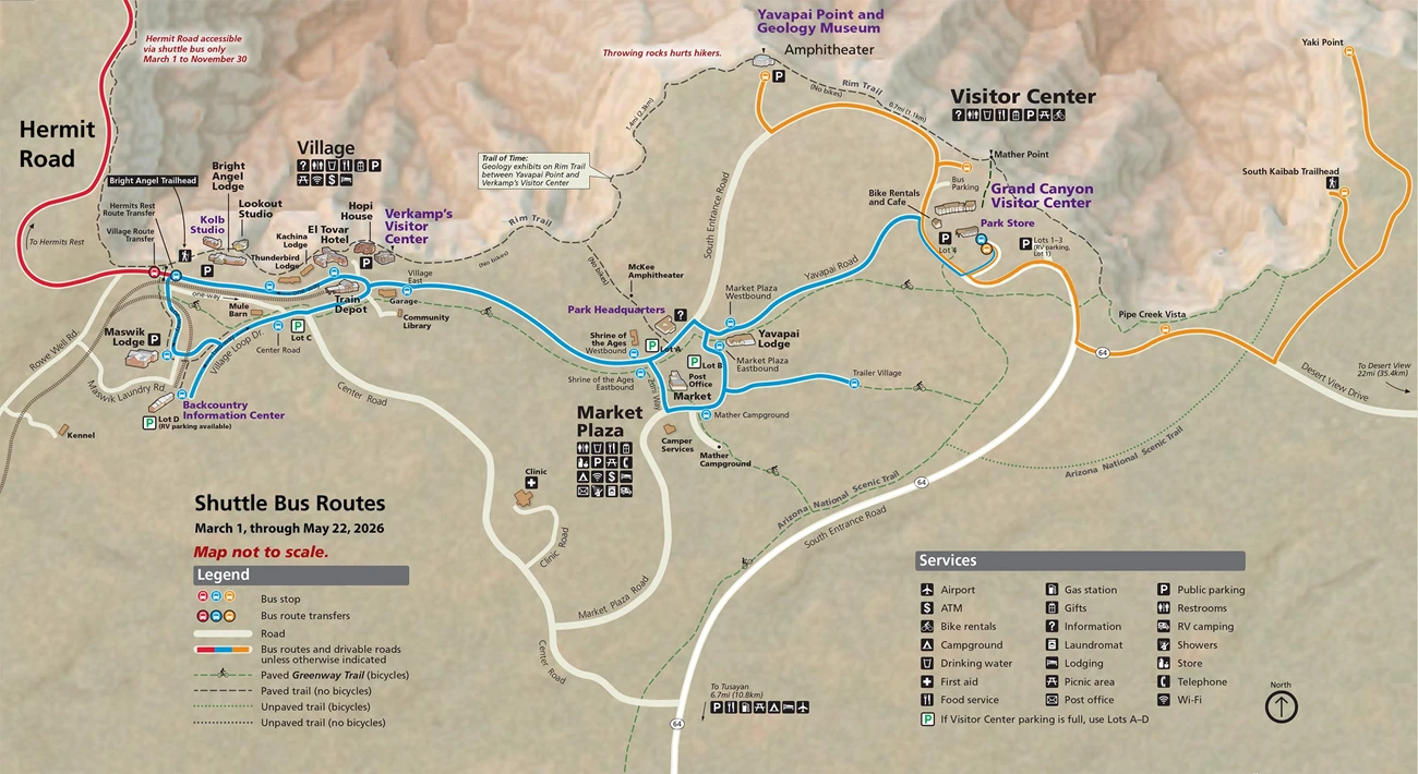
Shuttle System (South Rim Essential Guide)

The free shuttle system on the South Rim is one of the most useful tools for hikers.
Key Shuttle Routes
- Kaibab Rim Route (Orange Line)
- Connects Visitor Center to South Kaibab Trailhead
- Hermits Rest Route (Red Line)
- Access to scenic viewpoints and Rim Trail sections
- Village Route (Blue Line)
- Connects lodges, campgrounds, and visitor areas
Why It Matters for Hikers
- No need to worry about parking at busy trailheads
- Allows one-way hikes (start and end at different points)
- Reduces fatigue before and after hikes
👉 Most Grand Canyon trail maps include shuttle routes—use them to plan smarter hikes.
Essential Grand Canyon Hiking Tips

🌅 1. Start Early (Critical in Summer)
- Begin hikes before sunrise in hot months
- Temperatures can exceed 40°C (104°F) inside the canyon
- Early starts help you avoid heat exhaustion
💧 2. Carry Enough Water
- Minimum: 3–4 liters per person
- More for longer hikes
- Electrolytes are highly recommended
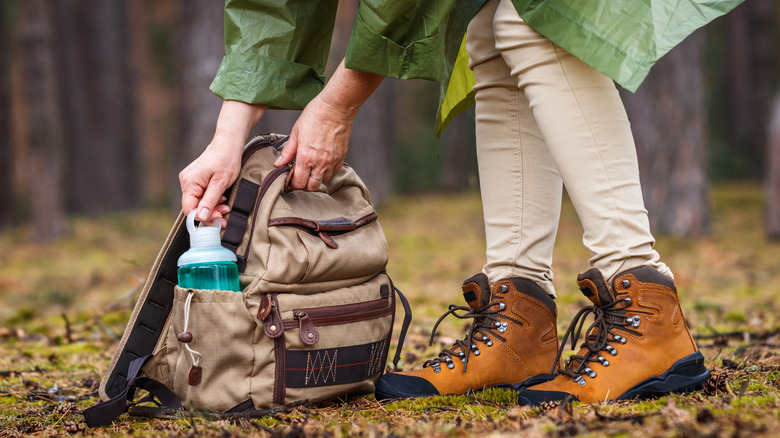
👟 3. Wear Proper Gear
- Sturdy hiking shoes with grip
- Lightweight, breathable clothing
- Hat, sunglasses, and sunscreen
🌡️ 4. Avoid Midday Hiking
- Heat peaks between 10 AM – 4 PM
- Shade is limited inside the canyon
- Plan your hike to be ascending early, not midday
⛰️ 5. Respect Elevation Gain
- Climbing out is much harder than going down
- Even fit hikers struggle with steep ascents
👉 Always check elevation on your Grand Canyon hiking trails guide before starting.
⚠️ Safety Tip (Read This Before You Hike)


Most Grand Canyon rescues happen for one simple reason: people underestimate the canyon.
🚨 Common Causes of Emergencies
- Dehydration
- Heat exhaustion
- Overestimating fitness level
- Not turning back in time
✅ How to Stay Safe
- Stay on marked trails at all times
- Use a reliable Grand Canyon trail map
- Don’t attempt rim-to-river hikes in one day unless highly experienced
- Listen to your body—turn back if needed
Golden Rule
“Going down is optional. Coming back up is mandatory.”
By using a detailed Grand Canyon hiking map, planning ahead, and respecting the environment, you’ll not only stay safe—you’ll enjoy one of the most breathtaking hiking experiences on Earth.
🗓️ Best Time to Visit Grand Canyon, National Park
Timing your visit can make or break your experience—especially for hiking.
🌸 Spring (March–May)
- Mild temperatures
- Ideal for longer hikes
- Trails are less crowded
☀️ Summer (June–August)
- Extremely hot inside the canyon (over 40°C / 104°F)
- Best for early morning hikes
- Use your Grand Canyon hiking map carefully to avoid overexposure
🍂 Fall (September–November)
- Perfect hiking weather
- Fewer crowds
- Best season for photography
❄️ Winter (December–February)
- Snow on the rim creates stunning views
- Some trails may be icy
- Fewer tourists
👉 Pro Tip: Always check elevation changes on your Grand Canyon National Park trails map—temperatures increase as you descend.
🌄 Top Attractions in Grand Canyon National Park
1. Mather Point
The most famous viewpoint—perfect for sunrise and first-time visitors.
2. Hopi Point
One of the best sunset locations on the South Rim.
3. Desert View Watchtower
A historic structure offering panoramic canyon views.
4. Bright Angel Trail Viewpoints
Even if you don’t hike far, short walks give incredible canyon perspectives.
🥾 Best Hikes in Grand Canyon National Park
Exploring the canyon on foot is unforgettable—but choosing the right trail matters.
🟢 Easy Hikes
Rim Trail
- Distance: Up to 13 miles (flat sections available)
- Best for: Beginners
- Highlights: Stunning views without steep descents
- Easily navigated using a Grand Canyon trail map
🟡 Moderate Hikes
South Kaibab Trail (to Ooh Aah Point)
- Distance: 1.8 miles round trip
- Elevation Gain: Moderate
- Best for: Scenic short hike
- Incredible panoramic views
🔴 Strenuous Hikes
Bright Angel Trail
- Distance: Up to 12 miles round trip
- Elevation Gain: 3,000+ ft
- Best for: Serious hikers
- Water stations available
North Kaibab Trail
- Remote and challenging
- Ideal for experienced hikers exploring Grand Canyon North Rim trails
👉 Important: Always consult a Grand Canyon hiking trails guide before attempting long hikes. Descending is optional—climbing back out is mandatory.
🏨 Where to Stay Near Grand Canyon National Park
داخل the Park (South Rim)
Tusayan (Just Outside South Entrance)
- Budget to mid-range hotels
- Restaurants and services available
- Great base for exploring
North Rim Lodging
- Limited but scenic
- Ideal for peaceful stays
Camping
- Mather Campground (South Rim)
- Backcountry camping requires permits
❓ FAQ – Grand Canyon Hiking Guide
1. Why is a Grand Canyon hiking map important?
A Grand Canyon hiking map is essential for understanding trail distances, elevation changes, water sources, and route connections. Unlike typical hikes, the canyon’s terrain is deceptive, and proper navigation helps prevent dangerous situations.
2. Which Grand Canyon trail has water stations?
The Bright Angel Trail has seasonal water refill stations along the route. However, water availability can change, so always check current conditions before hiking. The South Kaibab Trail has no water at all, so you must carry everything you need.
3. How much water should I bring for a Grand Canyon hike?
You should carry at least 3–4 liters of water per person, especially in warmer months. For longer hikes, bring more and include electrolytes to prevent dehydration.
4. What is the best way to plan a turnaround point?
Set a strict turnaround time instead of distance. For example, decide to turn back by a specific hour (like 10:00 AM), regardless of how far you’ve gone. This helps avoid hiking uphill during the hottest part of the day.
5. Can I hike from rim to river in one day?
While it’s possible, it’s not recommended for most hikers. Rim-to-river hikes are extremely demanding due to steep elevation gain, heat, and distance. Only experienced and well-prepared hikers should attempt it.
6. How does the shuttle system help hikers?
The South Rim shuttle system makes hiking easier by:
Providing access to major trailheads
Eliminating parking stress
Allowing one-way hikes (start and finish at different points)
Most Grand Canyon trail maps include shuttle routes, making planning much simpler.7. What is the biggest mistake hikers make in the Grand Canyon?
The most common mistake is underestimating the difficulty of the return hike. Many hikers go too far downhill and struggle to climb back up, leading to exhaustion, dehydration, or rescue situations.
8. When is the safest time of day to hike?
The safest time to hike is early morning (before sunrise to mid-morning). Avoid hiking between 10 AM and 4 PM, when temperatures are highest and shade is minimal.
9. Are Grand Canyon trails well marked?
Yes, major trails like Bright Angel and South Kaibab are well maintained and marked. However, you should still carry a reliable Grand Canyon hiking map or offline navigation for safety.
10. What should I check on a Grand Canyon trail map before hiking?
Before starting, always check:
Elevation gain/loss
Distance
Water availability
Trail connections
Shuttle access points